 Thanks for your interest in our apps!
We’re Cherie & Chris – two full time technomads (technology enabled nomads). Our apps are mostly a side hobby project for us, not our primary business focus. – they solve problems we’ve encountered in our own nomadic travels. That is their focus.
We have partnered with Hired Gun Software for continued development & maintenance of our apps, so that we can keep this product line sustainable.
Below are answers to our most frequent questions.
Update Status
Quickly check the update status for each of our apps, so you know if you have the most current versions and when you can expect the next update:
Coverage?
Standard map updates are always free for the life of the app, and updated 2-3 times a year, based on the last HD Map run.
HD Maps updates are on an annual subscription basis, and are issued quarterly at a higher resolution than the standard maps, and includes 5G mid-band & mmW, and satellite backgrounds on the underlaying maps.
Last HD Map Update: 1/2026 Next Projected: 4/2026
Last Standard Update: 11/2025 Next Projected: mid 2026
State Lines
We update this app roughly annually. We have shifted to updates coming out at the start of the year.
Last Update: 1/2026 Next Projected: Early 2027
US Public Lands
US Public Lands uses the Protect Area Database, and we update as theirs is updated. The current version is using PAD-US 4.0 – and 4.1 has been released (we are working on processing an update).
Last Update: 7/2024 Next Projected: Early 2026
FAQs
How can I get a Refund or Discontinue a Subscription?
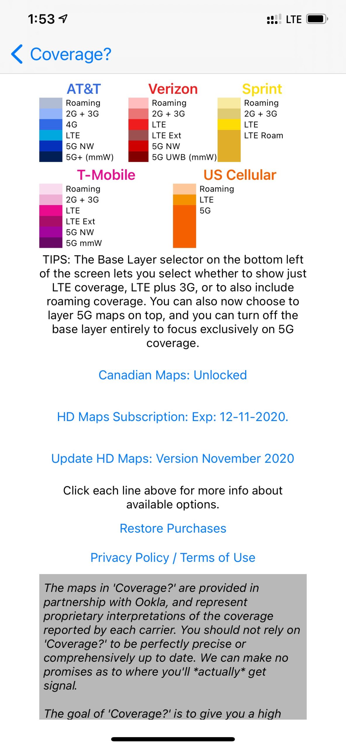
Coverage? - What's included on each's carriers layer?
Coverage? displays layers for each carrier. We’ve selected colors for each carrier that best matches their branding, and the darker the color indicates faster/newer coverage. You bring up a legend in the app’s info screen (top left hand corner).
For the major US carriers, the layers include 5G mmW & 5G mid-band (HD subscription only), 5G NW, LTE and roaming.
- Verizon – Displayed in shades of Red. Â ‘Extended LTE’ is shown as a duller red in the LTE layer.
- AT&T – Displayed in shades of Blue.
- T-Mobile – Displayed in shades of pink/purple. Extended LTE is included in a darker purple layer on the LTE layers
- Dish – Displayed in orange (Boost Mobile’s branding color), we show their native 5G coverage.
- US Cellular – Displayed in shades of magenta as they are in process of being acquired by T-Mobile, it includes their native 5G NW, LTE and roaming coverage.
- Bell, Rogers & Telus (Canadian Carriers) – These optional carriers available by in-app purchase display the LTE coverage map for each. Purchasing this option is a one-time lifetime access to the Canadian carrier maps.
Dish was added in February of 2025. As of May 2022, we no longer display 3G as the carriers will have this phased out by year end. Sprint has also be removed in Summer 2022.
Coverage? - How often are Coverage? maps updated?
Updating Coverage? maps is a very labor intensive process that takes a lot of time and bandwidth. Even with them now being provided by Ookla.
By the very nature of our apps, the updates will always be a bit out of date by the time they reach your device.
Ookla pushes new maps to us every quarter, which we push as in-app updates for HD Map subscribers ASAP. Â We release new standard map updates via app updates as needed (generally 2-3 times a year.)
Coverage? - What's the difference between Coverage? & Coverage? Lite ?
Coverage? Lite is essentially a free iOS trial of Coverage? – it allows you to use the full app with standard definition overlayable maps for a few sessions to check it out, before forcing you to pick a single carrier to continue for free.
Or, you can upgrade to the full versions in-app. Coverage? was originally launched long before in-app purchases were a feature, and originally we had LTE Finder as our free demo version – which Coverage? Lite replaces.
Coverage? for Android starts out as a free trial, with in app upgrades to the full versions.
Coverage? - I've spotted new coverage - where can I report it to you?
What makes our maps unique from apps like Rootmetrics  and Open Signal is they’re based on the carrier’s own maps. We cover the entire country, not just markets with an active user base submitting coverage reports.
For more how Coverage? can play a role in planning your travels around connectivity, refer to our guide: Travel Planning Around Connectivity.
Any new coverage that carriers have added will be picked up in the next update of Coverage? (providing the carrier’s themselves have updated their maps).
If you spot new coverage – enjoy! Â It’s always awesome to find the unexpected, isn’t it?
Coverage? - Why am I receiving different coverage than the app indicates?
All of our maps are derived from the carrier’s own maps at our last update. We can only report what they themselves report. And especially during a rapid roll out of a new technology – the carriers are turning on new services faster than even their own maps can keep up.
If you’re receiving different coverage than the app indications, here are the possible reasons why:
- The carrier just recently turned the service on in your area, and they haven’t even updated their own maps yet. We typically find it can take the carriers several weeks to update their own maps, ever after making a press release that they’ve turned on new service. We update based off of what is reported on their maps, not what they have announced.
- The carrier has updated their map, but it’s not yet reflected in our quarterly updated maps. It’s inevitable that as soon as we submit an update, a carrier updates their maps. Don’t worry, our next update will automatically capture the changes. We just simply can’t process an update every time  a carrier switches on a new tower.
- Carrier maps do not guarantee the coverage you’ll actually get – which can be impacted by your device, signal strength, surrounding buildings & geography, weather, your specific plan and tower load.
Please keep in mind, Coverage? is not intended to report the actual coverage received at a location – there are many other apps out there that take user submitted reports (we like the Sensorly app ourselves). However, these are generally only useful in populated areas with an active user base – not everywhere. We created Coverage? to give us an idea if our next travel destination or route has a chance of having signal.
Coverage? - Can you add more carriers or countries to the app?
Other US Carriers:
Frequent travelers are our target audience, so we focus on the major carriers.
Also keep in mind that many wireless carriers are actually MVNO’s who are re-branding bandwidth from one of the bigger carriers . Check this Wikipedia article for a listing of what networks various MVNOs use, which can better able to you to use Coverage? to find where you are covered with each.
Other Countries:
In June 2020 we were able to obtain maps for the three Canadian carriers, which is now available as an in-app purchase.
We are keeping an eye out for options to do the same with Mexico in the future.
The infrastructure of Coverage? could easily accommodate other geographic regions as separate apps. However there is extensive research to be done to determine each country’s primary carriers and how to capture their map data to be overlayed within the Coverage? model. This is a lot of labor intensive work that we just simply don’t have the time or funding for ourselves.
US Public Lands - How Accurate are the Maps?
The public domain source of our data is from the Protected Area Database (PAD-US 2.0) of the U.S. Geological Survey.
Please note, the USGS PAD-US database contains the “most up-to-date aggregation of Federal lands and waters†available, but this database is still evolving and some locations may not be listed and others may not have precisely accurate boundaries. Resolution across the nation may vary. And always remember – there may be private unmapped inholdings within any public lands – so always pay attention to local signage, indications, and information.Â
US Public Lands - How can I tell where it is legal to boondock / camp?
US Public Lands is not specifically a boondocking location app. It simply shows the boundaries of US Public Lands.
After finding where the boundaries are, and which department owns the land – you’ll need to further your research as to what activities are permissible and what permits might apply. Â There are links provided to each departments website on the Settings page to assist you finding this information.
For finding specific camping locations, you may want to utilize other resources such as FreeCampsites.Net or Campendium.com or many of the other boondocking resources out there.
US Public Lands - What's with the checkerboard patterns.. or that dark line off the California Coast?
These are actual US Federally held lands. In some locations, public lands were divided up in squares, creating the checkerboard patterns. And the water off the California is a BLM Monument called the CA Coastal National Monument.
US Public Lands - Is there a Color Legend for the Map Layers?
Yes! If you click on the ‘Gears’ button in the upper right hand corner you will be taken to the Settings screen (or pull down on iPad). The colored toggle buttons are color coded to match their map layers.
US Public Lands - Are in-holdings on Federal Lands shown?
The USGS PAD-US database contains the “most up-to-date aggregation of Federal lands and waters†available, but this database is still evolving and some locations may not be listed and others may not have precisely accurate boundaries. Resolution across the nation may vary. And always remember – there may be private unmapped inholdings within any public lands – so always pay attention to local signage, indications, and information.Â
US Public Lands - I've found some inaccuracies in the maps, can you fix it?
Our maps are provided by the public domain the Protected Area Database (PAD-US) of the U.S. Geological SurveyÂ
Any inaccuracies should be reported to them.. not us. We’re just the messenger. Thanks!
As always, you should always continue your research by consulting other resources as well. US Public Lands should only be used as a general reference point.
State Lines - How often is State Lines updated?
We intend to update State Lines annually.
We have to manually research each piece of information in State Lines and enter it ourselves – it’s not an automated process.
We strive to find the right balance between the expended effort and the benefit of having as up-to-date information as possible. After all, we depend on these apps in our own life – so it’s in our best interest to keep them updated. Rest assured, we’re on top of it.
State Lines - Can you add some new laws?
We always welcome suggestions for laws or regulations you’d like to see tracked in State Lines. We try to keep the content of the app focused on laws that impact travelers as they cross State Lines. If you have an idea, write and let us know (stateliness@technomadia.com). Â If you know of a public domain source for the data, please also include that.
State Lines - Why aren't gun laws covered in State Lines anymore?
We no longer track gun carry laws. We found this to be very complex topic, and not well suited to the short summarization format of State Lines.
We’ve heard great things about the Legal Heat app, which seems to be very comprehensive and written by gun enthusiast attorneys. We’ll let the experts concentrate on this one.
Are you available to develop an app for me?
Basically, no.
Our apps started as a side hobby and then we had to partner with an app developer to keep them maintained while we focus on our core business (the Mobile Internet Resource Center.)
If you have an app idea that could fit within the model of one of our existing apps – be in touch. All of our apps are designed to be used for different purposes. We’re always interested in ways to partner using our existing technology. But developing new technology? Probably not a fit for us.
Don’t see your question address above? Need additional assistance? Â Contact us at apps@twostepsbeyond.com.